Home
+
About me
+
E-mail me
+
Trips index
+
Canal game
Montgomery Canal (on foot), spring 2005
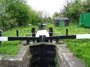
Bank Lock, on the navigable but disconnected section
Five-and-a-half days spent exploring the 56km of the Montgomery Canal,
on the English/Welsh border.
Parts of the Montgomery Canal are derelict and others are in the
process of restoration, but there is a continuous towpath
so the best way to explore it is on foot. We based ourselves
in a hotel in Oswestry, near the northern end of the canal, and made
daily excursions by car and on foot. You miss the fun of boating but you
can see a lot more walking, you can stop and look and you take many more
photos. We covered about half of the length of the canal, actually
about 53km of walking (as we had to walk out and back to the car),
sampling each section and the transitions.
We found the canal to be in six sections, going from north to south:
- A fully-restored navigable section connected to the English canal
system (Frankton Junct to Maesbury br 82, 8 locks, 11km);
- A de-watered section (to Llanymynech, 6km);
- A section restored but not navigable except by small portable craft
(to Arddleen br 103, 2 locks, 7km);
- A fully-restored, navigable but disconnected section, with a few boats
on it (to Berriew br 129, 11 locks, 19.5km);
- A section restored but not navigable except by small portable craft
(to Aberbechan br 153, 3 locks, 8.5km);
- A dry and derelict section, partly filled in and built over
(to Newtown, 3 derelict locks, 4km).
The wet but non-navigable sections are generally cut off by lowered road
bridges. The dry sections have these plus some official or unofficial
crossings over the bed.
Diary extract:
- Sun 2005-05-01 {18647}
- To Oswestry, the Wynnstay Hotel, right in the middle of the town, with
adequate car park. Unload, then out to Frankton Junc & walk to aqueduct
& back. Sunshine and warm. About 4 boats going down in the afternoon
session. Still the same Colin the lock-keeper. Spent some time sitting by
the Perry aqueduct, very peaceful, birds twittering, insects buzzing, the
very occasional boat, engine full on, crawling along; can't they see?
- Mon 2005-05-02 {18648}
- Bank holiday. Sunshine and showers, warm; shorts all day. Leave car in
public car park at Queens Head at ~9h, then walk along past end of
navigation at Maesbury then along dry bit as far as Crickheath Wharf. Some
of the dry bit looking like a canal, but in other places big trees growing
from the bed. Very few people about. One bridge in the dry section rebuilt
and waiting for water; guide says navigation expected to there by 2006 but
no sign of it (br 83, Redwith). Lunch on the way back at the Navigation Inn
at Maesbury. This a restaurant, but "bistro" at lunchtime, which means like
a pub but with excellent home-made food; run by two blokes. Rained on only
on the way back from here to Queens Head. Today ~13.5km.
- Tue 2005-05-03 {18649}
- AM mostly sunshine, aft sun & showers. To Llanymynech & park in
public car park by the Dolphin Inn. Section just E of here dewatered &
towpath shut for work on restoring a wharf. Walk along the other way as far
as br 96 site, taking in the two restored locks. Section is in water, but
not open for navigation, tho' there was one boat tied up in the town. Now
in Wales. Towpath soggy, so back via the roads. Follow the diversion past
the de-watered section to the E up to a disused and deckless railway bridge.
This is past the end of the section in water, E from here (about 500m E of
br 92) the bed is dry up to br 82 where we saw it yesterday. Over the
canal bed (a pipe culvert keeps the bed-level footpath crossing dry) &
into the heritage area, looking into lime kilns & at a huge chimney. This
got us back to br 92 & lunch in the Dolphin, we the only customers
12->13h. Aft on to br 104 (small area by br that we parked on), &
then walk S past restored and active locks to Bank lock just after br 109.
This is the section that has been restored to navigation & it looks the
part, except for some stretches where the surface is completely weed-covered,
even with plants growing on the surface. The rain started on the way back.
Did a quick dash to br 103 site, the limit of navigation: a culvert under
the A483 with a winding hole. Later drove up to look at this spot, &
also to site of br 102, an even gloomier culverting under the same A483,
Today 14.2km.
- Wed 2005-05-04 {18650}
- Started dull, but later some sunshine; cooler; no rain (yet). To br 115
Buttington Wharf, where there is a small, muddy car park. Walk thro'
Welshpool to Belan Lower lock at br 121. At brs 117 and 120 the canal has
been diverted thro' modern minimalist concrete box tunnels to bypass lowered
original crossings. Br 117 has no towpath, & the route to walk is not
clear at first sight over the road junction. Welshpool quite well done,
little dock with jetties, but no boats. Reverse walk back, diverting onto
roads in places to avoid a rather muddy towpath. Approx 10km. Back in car
to Welshpool & lunch at the Royal Oak Hotel (another Best Western like
the Wynnstay) - excellent ploughmans and sandwiches, & not expensive.
Walk to Welshpool and Llanfair Light Railway, but only runs weekends and
bank holidays. Then to Powis Castle, but that's closed also, can just drive
thro' grounds and photo the outside. So further on in car to find the
southern limit of the disconnected navigable section at Refail br 129,
which is lowered. Winding hole here cut into the garden of a house. Also
stops to look at Berriew aqueduct & Long Bridge (128). Back by a zig-zag
route, inc some of the hillside single-track roads above Belan & many
of the bridges we walked under yest.
- Thu 2005-05-05 {18651}
- Election day. Dull & sunny by turns, rained but not on us. To
Abermule & walk to Brynderwyn lock & br 146. Br 147 has a wall
between towpath and canal, & is next to a similarly-painted but much
bigger bridge over the Severn with letters proudly saying it is the second
iron bridge in the county of Montgomery, from 1852, but visible only to a
few fishermen on the river, & then hard to see for the trees. Then to
explore the southern end, starting at Becahn Brook aqueduct. Br 151 is a
fixed swing bridge by lots of new housing just starting to invade this
rural area. Walk S from here to find limit of water at br 153 &
derelict lock next to it, tree-grown and fenced off, with a rotting
keeper's cottage. Then dry bed to br 154 & another lock, also derelict,
but not so tree-grown. Bed is smooth kept grass. From here the line is
traceable but lost in parts alongside a foot path. Br 155 stands (just)
in a fenced-off area. S of here just looked from the car. Lunch at Abermule
Hotel, soup homemade leek & potato, & sandwiches, good, we the
only customers up to 13h at least. Aft to br 112 & go S to br 115 &
N to br 111 & Pool Quay lock, well-kept as they all seem to be on the
navigable section. Today 10km. Total so far 52.5km, on a 56km canal, so
leaving out the derelict end and with out-&-back we must have walked
half of it.
- Fri 2005-05-06 {18652}
- To Chirk Bank, & walk over aqueduct & thro' tunnel. Cutting a
bit muddy, so back over tunnel via road into Chirk, then back on canal the
other way to br 18. Moving boats make this canal different, plus paved and
ringed mooring places near the pubs. Much cooler today, tho' still some sun.
Frustrated in our intention of lunching at the Bridge Inn by its not opening
till 18h in the week, so drive into Llangollen. Lunch then inevitably at
the Bridge End Inn. Then a little walk up to the new marina & down to br
44, this span being the range of the new mooring charge: free for max 4h
before 16h, else 5L per day. This includes water and electricity at every
mooring (linear and marina).
- Sat 2005-05-07 {18653}
- Home.
 |
 |
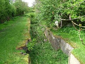
| Dolfor Lock, on the derelict southern end |
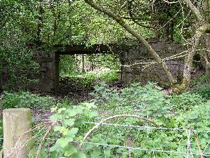
Bridge 155, a little south of Dolfor Lock |
© 2005-05-07..2006-01-08
Home
+
About me
+
E-mail me
+
Trips index
+
Canal game